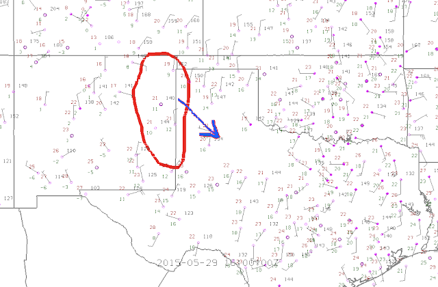
Starting in Amarillo (TX), lots of sunshine this morning across the TX panhandle so should help in increasing surface temperatures. A lot of anvil high cloud towards the border with W OK from a storm complex currently across eastern OK, but temperatures already into the low 70s F and dewpoints in the low/mid 50s F (so low 20s Celsius and 10-14C respectively). Initiation looks likely across E/NE New Mexico during the early/mid afternoon, with further storms developing downstream through eastern NM and eventually moving into W TX panhandle, before merging into a line of potential severe storms this evening. Chance of a tornado, but quite low with fairly dry surface air over New Mexico, and so storm bases will be quite high to start. However, given more sunshine today compared with yesterday, feeling a little more hopeful of seeing a decent thunderstorm if nothing else.
 |
| 16z (11am CDT) surface ons, highlighting zone of initiation and direction of travel through today |
Once storms merge into more organised line this evening the main severe risks will probably shift to strong outflow winds and small hail. Best chances of larger hail and perhaps a tornado with any more discrete cells this afternoon.
Current thoughts are to head to Dalhart (TX) with reasonably good road options and grab some lunch while reassessing how things look then. Certainly plausible we'll end up chasing SEwards back towards Amarillo, so perhaps a 3rd night in Ama? We'll see...
2015 STORM CHASE stats thus far:
McDonald's tally: 3
Applebee's tally: 2
Distance driven: 659 miles
States visited: 3
No comments:
Post a Comment