THU 29 MAY
After our overnight stay in Perryton (TX) we headed south through the TX panhandle, stopping at Buc-ee's in Amarillo (TX) en-route to our target of Brownfield (TX). After lunch, we ambled west to watch convection bubbling along an effective cold front stretched west-east to our north.
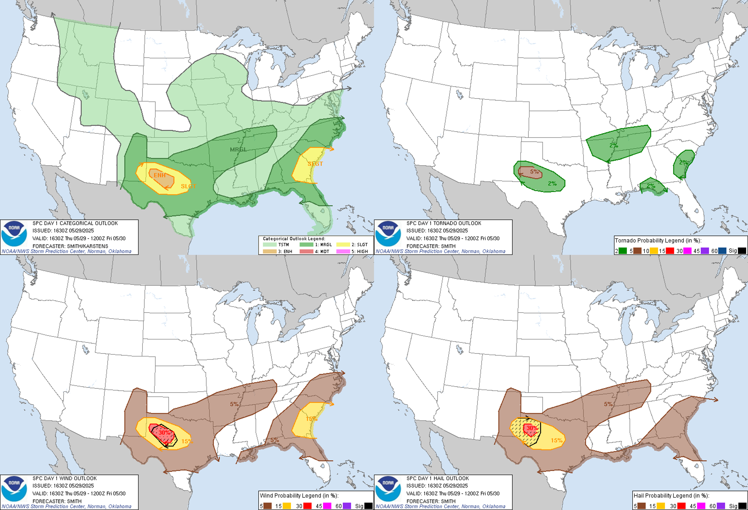
 |
| SPC forecast issued 16:30Z 29 May 2025 |
 |
| Quick stop at Buc-ee's Amarillo |
Eventually three cells developed, with strong inflow winds developing in our vicinity. We noticed two short-lived landspouts, revealed by dust circulating around their surface rotation. Eventually the three storms congealed into one large supercell that began to make better progress SE'wards, whipping up an incredible amount of dust. Another, slightly longer-lasting landspout became visible a short distance to the SE of Brownfield, again largely visible courtesy of the significant amounts of dust rotating around its lower circulation.
 |
| Watching a cluster of supercells mid-afternoon near Needmore (TX). Credit Chris Bell |
 |
| Texas Tech University doppler on wheels near Needmore (TX) |
 |
| Ground circulation a few miles SE of Brownfield |
Circulation filmed by Morrie Gooch
Eventually this storm became so shrouded in dust and precipitation that it became impossible to see any notable structure, other than just a wall of brown/black covering most of our northern sky - it was incredibly dark given the time of day (17:00 local). We trundled SE'wards to keep ahead of this storm... it became tornado-warned, although its presentation on radar looked rather messy and dust/precip wrapped.
 |
| A number of other storm chasers on Highway 137 between Brownfield and Lamesa, plunged into darkness by a wall of rain, hail and lifted dust. Credit Morrie Gooch |
We decided that it was unlikely that this storm would produce a highly visible / photogenic tornado given it was very outflow-dominant and had consumed so much dust, so instead we opted to park up on the outskirts of Lamesa underneath an agricultural hangar to let the storm pass over us. Within minutes the winds significantly whipped up, with torrential rain and hail lashing the side and roof of the hangar, and occasionally the car as the wind direction kept changing within the broader circulation of the storm.
 |
| Radarscope screenshot as the tornado-warned storm approached us on the south side of Lamesa |
Wind, rain and hail just south of Lamesa filmed by Berni King
 |
| Screenshot from the NWS Damage Assessment toolkit on 30 May, highlighting two confirmed EF-1 tornadoes either side of Lamesa - our location, whilst the storm was moving over us, is denoted by the filled red circle. Given the reported end and start time of tornado #1 and #2, an approximate timeline for the mesocyclone tracking through Lamesa is given by the white boxes putting it closest to us between 18:37 to 18:39, roughly the same time we noticed the sudden change in air pressure. |
The nearby mesonet station at Lamesa recorded a wind gust of 77 mph and just over an inch of rain. Perhaps more fascinating was the sudden changes in air pressure as the mesocyclone moved overhead, inducing a noticeable pressure sensation in our heads and ears, that kept waxing and waning with each wave of strong winds/heavy rain - akin to rapidly ascending/descending in a plane... I've never felt anything like it with a storm before. The mesonet station recorded a pressure range of 6 hPa over a 40 minute period.
 |
| Lamesa (TX) West Texas Mesonet station plot |
Once the storm had passed we tried to catch up with a separate tornado-warned storm to the west of Abilene (TX), but it began to weaken / become outflow-dominant before we reached it, so in the end we gave up and grabbed some food and a hotel for the night in Sweetwater (TX). New, sub-severe cells developed nearby/overhead, and produced some decent CG lightning whilst we sat and ate dinner. All-in-all a decent chase day, enhanced by an excellent road network in this part of west Texas which enabled us to keep relatively close to the storm with lots of exit options.