Saturday 16 June 2012

2012 Day 10 - Dallas Fort Worth (TX) to Vidor (TX), Liberton Co (TX) thunderstorms

Sat 16 Jun

After a breakfast stop and dropping Pete off at DFW airport, we drove back to Vidor (TX) during the afternoon. The majority of the journey was sunny and very warm (in the 80s F), but as we left the I45 at Conroe (TX) and headed eastwards to Cleveland (TX), there was some significant convection taking place, with a N-S line of thunderstorms to our east. We drove through them as we approached Cleveland (TX), and it seems some parts of the town had experienced a powercut, and there was a lot of standing water - some roads were flooded, and many ditches were very full.

On leaving Cleveland (TX) a few flashes of lightning occurred, making it the 10th consecutive day of lightning. Some nice low cloud bases were also evident, with an interesting formation from rain-cooled cumulus to our west. They started to form some nice wave patterns, almost like Kelvin–Helmholtz waves...
Wave patterns starting to form...
Arriving in Vidor (TX), a new outflow boundary eventually crossed the area as showers on the seabreeze front approached (but decayed before they reached us). Some nice, low-level ragged cumulus were visible, with a notable increase in wind speed for a short period, but sadly with upper ridging taking place no thunderstorms occurred...
Gust front moving overhead at Vidor (TX)

Friday 15 June 2012

2012 Day 9 - Wichita (KS) to Dallas Fort Worth (TX), baseball and fireworks

Fri 15 Jun

No chasing today as we had to make sure Pete was at Dallas Fort Worth ready for his flight on Saturday evening. As such, we thought we'd take the opportunity to drive to DFW early from Wichita (KS) to watch a baseball game (Houston Astros vs Texas Rangers) at the Ballpark in Arlington (TX) during the evening - first one I'd ever been to, but great fun and a really good atmosphere!
The game ended around 10:15pm, followed shortly afterwards by a fantastic fireworks display. And of course throughout the game we could see cumulus congestus forming into a line of thunderstorms well off to the east, and as the sun began to set some quite frequent distant lightning flashes could be observed, illuminating the structure of the storms - thus also making it the 9th consecutive day of lightning...

Thursday 14 June 2012

2012 Chase Day 8 - Kansas Multicells and MCS

Thu 14 Jun

Today's action was primarily focussed on forcing from a cold front providing the required lift to generate widespread scattered thunderstorms, which were then forecast to merge into a long MCS (mesoscale convective system) in the evening. And that's exactly what happened...

We left Goodland (KS) and travelled east to Colby (KS) where we observed cumulus rapidly growing along the front. A few thunderstorms formed to our north towards the border with Nebraska, so we drove northwards, but were treated to a nice display of mid-level funnels from a new cell developing along the same line to our west.

Nevertheless, the storm to our north was become quite substantial with frequent CGs and eventually formed a nice-looking wall cloud, which at times looked like it was trying to form a few funnel clouds, but alas it failed. We chased this storm for several hours, taking deliberate moves southwards and eastwards to both avoid the damaging hail in the core, and to get the best view of the potential wall cloud and cloud base.

Eventually we got caught up with the gust front, and were slammed by winds gusting in excess of 50mph at times, kicking up a significant amount of dust and covering exposed portions of our white car in dust. The storm started veering more southeastwards, so after briefly bumping into the Netweather Tour 5 chase team, we parked up in Stockton (KS) hoping to experience some very heavy rain and moderate hail.

Sadly the storm failed to produce the hail, but did give us some reasonable rain and frequent CGs. We decided to head south towards Hays (KS) via Plainview (KS), and basically moved parallel with a line of storms, and thus much of the journey saw strong westerly winds, heavy rain, frequent lightning and some hail at times.

As we got onto the Interstate at Hays (KS) we briefly saw things dry up, but the cold front began to accelerate, and forced all of the multicell storms to our north to move southeastwards, and we became stuck under the same line of storms for the next 2 hours since we were moving at roughly the same speed as the storms were due to the poor visibility and road conditions.

There was enough hail at times to cover the road, causing almost winter-type driving conditions. Lightning became incredibly frequent with a serious quantity of CGs - in fact one CG hit the ground 20 metres to our north on the other side of the carriageway, with instant gunshot thunder. There was very heavy rain throughout the journey to Salina (KS) and then south on the I35 to McPherson (KS), with the temperature stationary at 65F, before we eventually outran the front edge of the LEWP (line echo wave pattern), arriving at a dry and warm (86F) Wichita (KS), before the storms moved overhead later in the evening.

ADDITIONAL
Doppler radar of the MCS line (LEWP) this evening

Wednesday 13 June 2012

2012 Chase Day 7 - Sheridan Lake (CO) and Cheyene Wells (CO) updrafts and anvil

Wed 13 Jun

Main worries for today were over the residual cloud from the previous night's storms. Indeed, we were woken by a thunderstorm at Lubbock (TX) late in the night, thus adding another consecutive day of witnessing lightning...

Most of the computer models were indicating storm initiation around SE Colorado, so we drove north via Amarillo (TX), Dumas (TX), Boise City (OK) and Springfield (CO). Along the route I kept close inspection to any signs of significant convective development, and while there were some convection occurring along the Rocky Mountains way to our west, the process by which those showers were forming meant that they would have died by the time they reached us.

We waited in Springfield (CO) for quite some time, hoping that something interesting may develop because until this stage the atmosphere looked pretty capped. A couple of notable towers grew into cumulonimbus' to our north and northwest, with some good anvils spreading eastwards from their cores. Unfortunately because the surface air was incredibly dry, the clouds were essentially very high-based, and all precipitation was evaporating before reaching the ground (ie virga).
Dry convection over Colorado, with new updraft towers forming on the western flank
It became apparent that today just wasn't going to produce any severe storms, so we decided to spend the time we had dedicated to shooting and filming a couple of very high-based 'dry' showers, with constant updrafts being formed to the west throughout the course of the afternoon. The northern-most cell near Sheridan Lake (CO) had some lightning detected from it, but alas we never saw any, and it was probably quite high based.

I filmed a short (4 sec) timelapse of some new updraft towers developing on the western flank of the cell - the shake to the camera was caused by the strong westerly winds present across The Plains...


By mid-evening the showers were showing clear signs of collapsing, so we decided to give up for the day and head for Goodland (KS) to stay the night and be in a reasonably good spot (we hope) for Thursday's potential storms!

ADDITIONAL
Satellite imagery showing the anvils visible from Space

Tuesday 12 June 2012

2012 Chase Day 6 - Roosevelt Co (NM) Supercell

Tue 12 Jun
THE BIG ONE

Starting the day at Wichita Falls (TX), we initially drove to Amarillo (TX) to grab a bite to eat, and to assess the situation. We started to feel a little nervous that we were located a little too far west, so we drifted southwestwards towards Clovis (NM), just over the border into New Mexico.

Once we'd had a proper look at the latest data, and we had restarted the car using some jump leads provided by a very kind local, we headed towards a developing thunderstorm west of House (NM). Initially only the anvil top was visible, but as we neared it the full structure became apparent.
Right-mover supercell approaching from the northwest near House (NM)
Strong inflow sucking dust into the supercell over De Baca county (NM)
By now the anvil had started dropping a few CGs nearby, and you could hear the suspended power lines ahead starting to buzz more frequently. We wanted to get some better pictures of the stom's structure, so we decided to head south towards Melrose to gain some distance between us and the ever-approaching storm.
Since the storm was moving slowly southeastwards, we had to get ahead of it to get a nice view of the structure, so we headed south of Melrose along a dirt track...
Flanking line extending to the west, and providing new towers for sustaining the updraft
Striations that suggest the supercell has a clear mesocyclone, and is therefore rotating helping to separate it's updraft and downdraft and allowing it to intensify
Cloud base was quite high initially, but began to lower into the evening as surface temperatures fell and the surface layers began to moisten
To our west we were treated to a spectacular sunset...
...while to the south was a nice long line of distant anvils, lit up by the setting sun:
As the storm continued to rotate, some magnificent mammatus rapidly formed in the mid and upper portions, and on the anvil, while a new updraft forming on the northwestern flank began to form a funnel cloud for a short period of time.
Mammatus rapidly formed on the upper portions of the supercell
A new updraft started to spawn a funnel cloud for a short duration
Anvil shadow
Darkness began to fell and the supercell really started to kick out frequent lightning with several CGs from the new updraft tower.
CG from the new updraft
New horizontal funnel cloud forming to the left of the photo
The road network in this part of New Mexico are pretty poor, so we had to drive to the northern side of the storm in order to keep up with it - by this stage it had passed through Melrose, leaving a carpet of sizable hail on the ground. The storm began to show indications on doppler radar of a potential tornado, and as a result the National Weather Service issued a tornado warning for the thunderstorm as it moved across Floyd (NM) and later Dora (NM).

We waited a few miles west of Dora while the core of the storm passed over the small town, with the sound of distant tornado sirens being carried on the wind.Once they had ceased we drove into Dora, and the western side of the town was covered in golf ball sized hail, with some minor damage done to trees and streetlights visible. Also worth bearing in mind that the hail would've had 10-15mins worth of melting before we arrived, so they were quite likely initially larger than when we came across them. There was also some flooding in central parts of the town, and reports of a rain-wrapped tornado.
Golf ball (or larger) sized hail at Dora (NM)
There is something quite strange about hailstones of this size (or larger) falling into surface temperatures in the 80-90s F (27-32C) - it just goes to show how powerful the atmosphere can be...

ADDITIONAL
Doppler radar showing potential tornado location, with Severe Thunderstorm (Red) and Tornado (Pink/purple) Warnings

Monday 11 June 2012

2012 Chase Day 5 - Stephens Co (TX), Young Co (TX), Clay Co (TX) supercell

Mon 11 Jun 

After spending the night in Ponca City (OK), and consequently allowing the cold front to move over us during the overnight period, we headed south on the I35 via Oklahoma City towards the Texas border, passing through the cold front to the other side once again. Initially the plan was to chase around the Red River, but as we moved farther ahead from the cold front, it became apparent that the cap was too strong to be broken, despite surface temperatures reaching 103F (39C) on the in-car thermometer.
Car thermometer showing 103F close to the border with Oklahoma and Texas

Instead, we decided to head towards a newly developing cluster of storms close to the I20 corridor west of Dallas (TX). The bulk of them were moving southeastwards, but one supercell began to split, with the left mover heading in a more northeastwards direction, very slowly towards us.

We chased towards the storm, and took a road south from Graham towards its core, but stopped to take the opportunity to snap some photos. At this stage the anvil had covered 180degrees of the sky, and rain and small hail started falling. Moreover, there were numerous CGs being produced from the anvil, with almost instantaneous loud thunder. The storm, while heading straight for us, developed new updrafts on it's western flank, and we decided to try and head north to avoid the damaging hail that had been reported in the core.
Approaching the gust front
Some nice shear funnel clouds in the mid-layers

Heading northwestwards, we were hit by 50mph winds as the outflow briefly caught up with us. We passed through Newcastle (TX) and stopped at Olney (TX) to observe a new tower shooting rapidly up on the eastern flank of the storm - this really was a monster of a storm.
Looking back at the approaching gust front
New tower (updraft) shooting up on the eastern flank

We were desperately trying to get to the southern side of the storm (currently on the north side) so that we could observe it much better, but this monster just kept growing linearly to the east and west, really inhibiting our chances. We tried several routes westwards, but it kept backbuilding to the west on the flanking line. By now it was starting to get darker as the sun started to set, with a brilliant orange sunset through the anvil haze.

Just west of Archer City (TX) we parked up to watch the gust front come in, with lightning (although mainly IC) becoming very frequent as darkness fell, and the wind picking up considerably as the gust front approached. It also felt noticeably cooler as well.
Gust front approaching from the South West
Gust front approaching near Archer City (TX), with lightning becoming more frequent
The rain was fast approaching so we jumped back in the car and raced eastwards to Windsthorst (TX) to get ahead of the gust front again and to shoot some lightning. Then heading north, we decided to punch the core of the storm by parking in Henrietta (TX) and letting the entirety of the storm move across us.

We were treated to strong winds, very heavy rain, and some hail, but not a huge amount. This was all accompanied by frequent lightning, the majority being CC, but several close CGs were spotted at times, but the sound was often muffled by the strong winds and heavy rain in the downdraft.
CC lightning at Henrietta (TX)

CG lightning at Henrietta (TX) - shame the shot was out of focus!

Eventually the storm passed to our east, and looking back at the radar loops it seems that the main hail core went to our south east. Nevertheless it was a cracking storm, definitely better than anything I have ever witnessed in the UK!

ADDITIONAL
Radar screen grab

Sunday 10 June 2012

2012 Chase Day 4 - Hutchinson (KS) supercell

Sun 10 Jun

Today we drove from Okarche (OK) to Newton (KS), leaving at midday and arriving at ~3pm. We had our sights set on somewhere just north of Wichita (KS) for some supercellular storms to develop, based on various model output. After grabbing a bite to eat, we sat in position hoping the approaching cold front would be enough to break the cap and allow thunderstorms to develop.

By late afternoon, storms had already fired in the far north of Kansas, and we began to feel slightly nervous that we might've been too far west given the eastward-moving cold front. So we drove west to Florence, and parked up at a gas station to re-asses the situation.

It became apparent that there was more significant cumulus growth right on the back edge of the cumulus field, and that we were probably positioned too far east, so naturally we drove north to Marion, then west again, parking up at Hillsboro. By now we could see some low-topped anvils in the distance, and radar returns suggested some deeper convection was starting to form way to our west.

We chased north then west again, and found a hill at Roxbury where we had a really good view of the western sky.
Our chase vehicle, parked at Roxbury
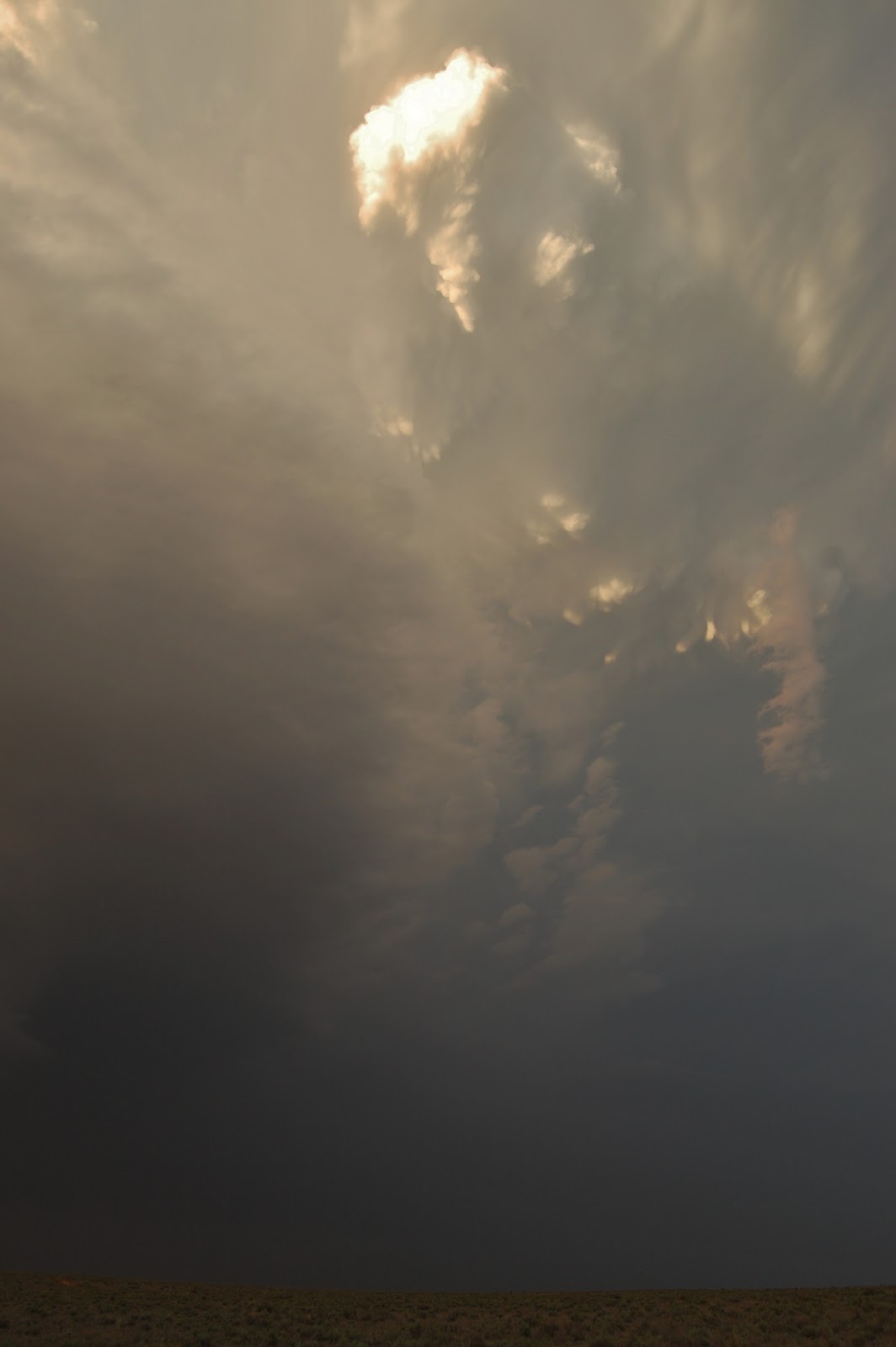
The first couple of anvils really struggled and began to shear off, and the cloud bases disintegrated very quickly, later confirmed by the drop in radar activity. One anvil debris went overhead with some mammatus on it's southern edge.
Waiting patiently we were finally rewarded with some new shooting towers to our southwest over Hutchinson, forming a new anvil at a much higher level than the previous one, indicating the cap was broken.
New anvil began to form at a significantly higher level than the previous anvil
It was at this point that the Weather Radio raised the alarm that a severe thunderstorm warning had been issued for large hail and gusty winds.
This was the beginning of a supercell which despite the frontal progression eastwards, became very slow moving, and over time began to head southeastwards, against the main northeastwards flow.
We chased southwards to Canton, where we stopped to take some photos of this storm in it's mature stage - some signs of lowering along the wall cloud, but I remain to be convinced that a funnel was forming.
Flanking line allowing new towers to form, with the back-sheared anvil also visible
As the sun set, a new anvil with overshooting top was visible to the north
Nice crisp edge to the supercell's anvil to the west, with some low-level fractus clouds in the foreground
At this stage the storm wasn't producing a huge amount of lightning, but appeared to be back building on the radar, so we headed southwards again as darkness began to fall to Park City, then westwards towards Maize. As the sun set, lightning became very frequent, but largely inter-cloud with quite a few anvil crawlers - very little in the way of CGs (cloud-to-ground).
Plenty of IC and CC lightning, and anvil crawlers

We pulled over to take some lightning shots in the dark, but sadly after a short while the storm ceased to produce anymore lightning. It was also apparent that the base had really become high-based, and over the next 30mins the storm vanished on radar - surprising given the additional forcing of the cold front (it wasn't purely generated by surface temperatures). Reports from the SPC suggest hail up to 1.75inches (4.44cm) in diameter fell in parts of the storm.

Nevertheless, it was a cracking day with being able to pinpoint the only supercell for miles 24hours in advance. It also makes it the fourth day of lightning in a row.

ADDITIONAL

Radar for the storm, including the Severe Thunderstorm Warning box
Visible satellite image of the supercell/anvil over S-C Kansas

Saturday 9 June 2012

2012 Position Day 3 - Vidor (TX) to Okarche (OK)

Sat 09 Jun

Today we woke up at 4am to make the long drive (10 hours or so) to Okarche (OK) from Vidor (TX). This allowed us to pick up Pete, our new chasing partner, and to position ourselves ready for Sunday's storm potential which at the moment looks to be somewhere around and to the north/east of Wichita (KS).

Majority of the journey went smoothly, but an accident on the I35 south of Norman (OK) meant we had to leave the interstate for a brief section to avoid the quasi-stationary queues, and rejoin the interstate further North.

During the first part of the drive (5-6am) a few cells over the Gulf offshore from Texas produced lightning which initially lit up the sky, but as the sun rose this became increasingly only visible in the cloud structure themselves. Nevertheless, although technically not close to us, this makes it the 3rd day in a row where lightning has been visible...

Friday 8 June 2012

2012 Chase Day 2 - Vidor and Beaumont (TX)

Fri 08 Jun

A quiet day today as we were basically waiting to leave early tomorrow morning to drive north to Oklahoma. A few high-based storms developed just to the south of Vidor early in the evening (5-6pm) producing some nice rumbles and some rain (probably a rainbow too given that it was still sunny).

After dinner we decided to chase an outflow boundary that was racing quickly westwards ahead of a large cluster of thunderstorms over Louisiana. We started driving as the outflow arrived at the house, but managed to get just ahead of it on the I10 to stop and take a few shots before it caught up with us. A notable increase in wind was felt as it came over, and some really low scud, rotating for a time before being lifted back into the base of the cloud.
Outflow boundary moving overhead on the I10 west of Vidor

A noticeable increase in wind was observed at the surface as the gust front passed overhead

Some signs of rotation from the gust front before it lifted again
We hopped back in the car to try and get ahead of the outflow boundary, and managed to several miles west of Beaumont. By this stage it had developed a really nice structure (sadly no camera on this venture either due to the unplanned nature, so no photos sadly), and the wind really picked up as it came over.

We decided to stay in this position and focus more on shooting lightning pics as darkness fell, and the storms over Louisiana came towards us. Initially lightning was primarily to our NE and SE from two separate cells, but became more extensive and it appears a new cell formed right over our heads on the outflow boundary, producing lightning to our west as well.

By now it was getting really dark and rain started falling so we decided to head back, passing through several cells which produced some moderate rain and frequent lightning.