Main worries for today were over the residual cloud from the previous night's storms. Indeed, we were woken by a thunderstorm at Lubbock (TX) late in the night, thus adding another consecutive day of witnessing lightning...
Most of the computer models were indicating storm initiation around SE Colorado, so we drove north via Amarillo (TX), Dumas (TX), Boise City (OK) and Springfield (CO). Along the route I kept close inspection to any signs of significant convective development, and while there were some convection occurring along the Rocky Mountains way to our west, the process by which those showers were forming meant that they would have died by the time they reached us.
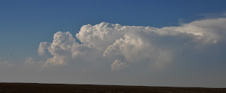
We waited in Springfield (CO) for quite some time, hoping that something interesting may develop because until this stage the atmosphere looked pretty capped. A couple of notable towers grew into cumulonimbus' to our north and northwest, with some good anvils spreading eastwards from their cores. Unfortunately because the surface air was incredibly dry, the clouds were essentially very high-based, and all precipitation was evaporating before reaching the ground (ie virga).
 |
| Dry convection over Colorado, with new updraft towers forming on the western flank |
I filmed a short (4 sec) timelapse of some new updraft towers developing on the western flank of the cell - the shake to the camera was caused by the strong westerly winds present across The Plains...
By mid-evening the showers were showing clear signs of collapsing, so we decided to give up for the day and head for Goodland (KS) to stay the night and be in a reasonably good spot (we hope) for Thursday's potential storms!
ADDITIONAL
 |
| Satellite imagery showing the anvils visible from Space |
No comments:
Post a Comment