WED 04 JUN
No great rush today as initiation was expected to be late in New Mexico, but we still had a good 6 hour drive to get from our overnight stay in Decatur (TX) to reach our target of San Jon (NM) via a lunch stop at Amarillo (TX). We bumped into Simon Lee again at Buc-ee's in Amarillo, and arrived in San Jon around 5pm, giving us a couple of hours to chill before initiation, in the company of two Doppler on Wheels.
Right on cue at 7pm a thunderstorm developed to our southwest, so we drifted west along Historic Route 66 to Lesbia (NM) where we core-punched the storm as it became severe warned, producing copious amounts of hail covering the road. What was particularly cool was the visible transition from heavy rain to hail, with an obvious wall of white in front of us marking the start of the hail. This cell crossed I-40 and we then followed it back east to San Jon and Glenrio (NM), stopping several times to watch its structure and rotation.
Punching through the hail core near Lesbia (NM)
 |
| Doppler on Wheels heading south near Lesbia (NM) |
 |
| Hail core easing away to the north near Lesbia (NM) |
 |
Core punching at Lesbia (NM)
|
 |
| Copious amounts of hail at Lesbia (NM) |
 |
| Copious amounts of hail at Lesbia (NM) |
By now, as it crossed the state lane into Texas and darkness descended, the supercell was making more of a right move and heading ESE'wards, soon to cross I-40 once more. Due to somewhat limited road options we decided to keep ahead of it and drove some distance down I-40 to Vega (TX), then taking the south road towards Hereford (TX). We parked up for a while to watch the constant lightning illuminating the shelf cloud and threatening wall cloud. Other chasers reported a brief tornado around this time, although it was incredibly hard to see due to the darkness and rather ill-defined/ragged nature of the wall cloud.
 |
| Supercell near Glenrio |
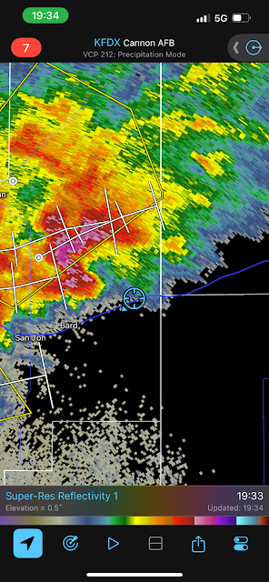 |
| Screengrab from Radarscope of our location (blue circle) relative to the supercell |
It was getting late now (10pm onwards) and given it would be very hard to see any tornado in the dark we opted to head NE'wards to Canyon to find somewhere to shelter the car and let the storm move over us. In the minutes preceding the onslaught of rain and hail, a prolific lightning display took place above our heads, with constant flashing illuminating the ominous shelf cloud gradually approaching from the west. Eventually we were hit by the rain and hail, with some pieces as large as ping pong balls with plenty of shredding of vegetation. Wind was not especially strong in the part of the storm that hit us, but a more substantial bowing segment passed to our south did produce a reported 81 mph gust at Tulia. Once the storm had moved through we found a hotel for the night in Canyon, but with several more thunderstorms moving through at times.
 |
| Ominous shelf cloud approaches Canyon TX from the west, whilst constant lightning flashes above |
 |
| Hail at Canyon |
 |
| Hail at Canyon besides a Quarter coin (24 mm diameter, suggesting hail was >30 mm in diameter) |
Large hail falling in Canyon (TX). Credit Chris Bell


No comments:
Post a Comment